

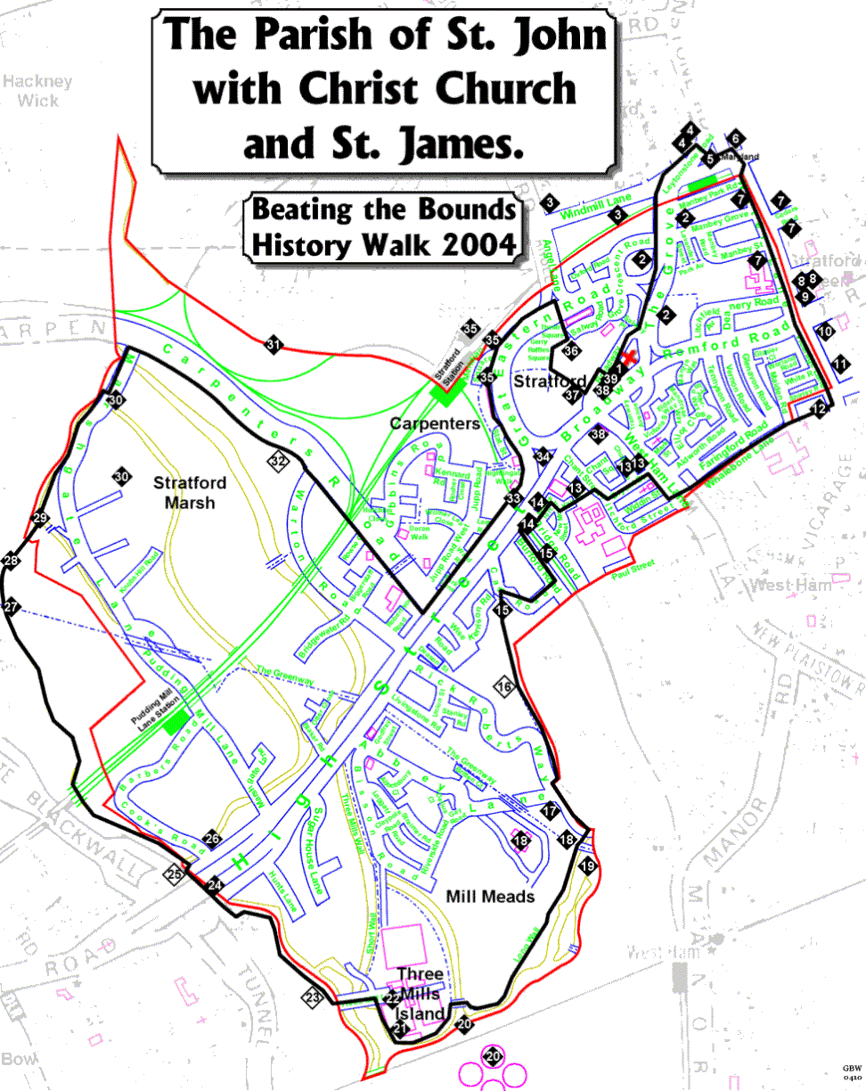
On Sunday October 24th 2004 Chris Aubrey guided a party of about 20 people around the bounds of the parish for two purposes. Firstly, a pleasant walk and a rough history of the area and Secondly, to continue the age old tradition of "Beating The Bounds" of the parish.
It is actually quite impossible to follow the precise boundary of the parish as it cuts through buildings, across and along railway lines and runs down the middle of rivers, so we chose a route which would take us as close as possible to the bounds and not be too unpleasant. It was suggested that James may, however, like to attempt the northern Carpenters stretch of the actual boundary as it would entail climbing the spill mound from the Channel Tunnel Rail Link excavations, which was, at that time, some six storeys high, he declined.
Below is the 'Rough Guide' we produced to accompany this walk and a map of the route can be found by clicking this link. You may wish to take the walk yourselves, however, the guide is very rough as Chris provided the detailed information verbally as we were walking the route, with assistance from David and Carol, also, be aware that the canal towpaths, from 23 to 30, can be muddy and slippery so care is needed.
PLEASE NOTE: This route was taken in 2004. The section from 25 to 32, below, is now within the Queen Elizabeth Park and has changed completely.
- Begin at St. John's Church (1834) and the Martyr's Memorial for 1556 (1880s). Enter Broadway.
- Walk north along the Grove. By the Library the Edith Kerrison Memorial. On the left St Francis Friary. Long associated with the poet Gerard Manley Hopkins. On the right old music-hall, canopy recently removed!!!
- To the left is Windmill Lane [windmills here once]. Site of Railway Engineering Works. Angel Cottage at end - well worth a look. Railway Tavern opposite!
- Turn right to Maryland Point, named after a 17th century local who made his money in the colony of Maryland. Note the old Victorian shops on the left, conspicuous by their chimneys and traces of Victorian enamel-work high up under the eaves. Site of Brewery/Hops.
- Cross to the traffic-island. See the repainted Victorian "stink-pipe", letting foul air from (now closed) subterranean toilets.
- Pass on the left the site of old Presbyterian Church (1870) now a new tower-block. Turn south (left) down Water Lane (eastern Bounds)
- Head south. Pass Manbey Estate & old butchers shop to the old Deaf School (now part of Sarah Bonnell School, an 18th century foundation for girls). Opposite, in Cedars Road, old church of St Stephens & remains of Stratford Artillery Barracks.
- Ahead old high Victorian Public Library, now part of University of East London & statue of a lost and perplexed William Shakespeare
- At junction of Water Lane and Romford Road see [behind fence on corner] stone-and-brass memorial to site of original Stratford Common (village green, Gallows Green).
- Cross Romford Road. Site of London Electricity Board offices, which used electric vans in 1930s
- Walk south down Vicarage Lane (old link to Late Norman parish church, 200m further on). Beyond flats, on left, see cobbled lane with, until recently, old wagon mark-stone.
- Cross Lane and go down between flats. Enter old pedestrian walk Whalebone Lane. Name origin obscure, but whalebone was once used for making ladies' corsets. (On West Ham Lane terrace houses still bear old name (up high above shops)). Emerge on West Ham Lane.
- Cross Lane and descend road almost opposite (Bryant Street). Original St Johns Vicarage stood on corner here. See on right Memorial Arch to Queen Mary's Hospital for the East End. At bottom cross and enter lane between Magistrate's Court and School. Possible Curwens Chapel site, inventor of Tonic Sol-fa system. Turn right by gardens. Follow road to Bridge Rd.
- Emerge on High Street between old Borough Theatre (now the Rex) and old Stratford Market Station. New Education offices and Stratford station opposite. Turn left
- Over Railway Bridge turn left into Burford Road. Old market hall. Turn right before end into Cam Road then left into green lane. This is a filled-in canal, the Channelsea, a parish Bound.
- Walk along canal pathway. On right hand side are old walls of original canal, with mooring rings for barges/narrowboats.
- At end of path, turn right and emerge onto Abbey Lane (named after mediaeval monastery once in this area), ahead are Victorian cottages built at time of construction of Bazalgette's sewage pumping station, turn left and cross to Greenway ahead.
- Ascend stone steps to Greenway. You are standing on a 150 year old Sewer, carrying London's waste to Beckton: built by Bazalgette, an unsung London hero. See Bazalgette's sewage pumping station on right.
- See Channelsea River flats: this is tidal (note direction of flow of waters) (and dangerous). Follow tarmac & gravel path opposite (heading south).
- Keep River to left, follow path. Nature area. See listed Gas-Holders ahead. Cross Prescott Channel by metal bridge. Remains of old Euston Station Memorial Arch used to plug hole in bottom of river here.
- Follow river path to left and long painted wall, by southern Bound of parish. Turn corner and see panorama of Three Mills tidal complex. These mills go back more than a thousand years. Largest two-way tidal watermills in Britain, taking advantage of tides in Thames (not far away)
- Emerge in paved courtyard by Clock Mill. Left a footbridge to Poplar (and Tesco's) (superb lock-gates)
- Cross footbridge then immediately right and down ramp. Walk along towpath until BOC depot.
- See ahead, along river, site of original Bow Bridge. Turn left then right (north) at top heading towards Bow flyover.
- Cross the High Street under Flyover (with very great care) and descend slope to (canalised) River Lea/Lee. The many waterways in this area are held to have been first controlled by King Alfred the Great as part of his campaigns against the Vikings (800s).
- Immediately to your right is Bow Back River, another part of the old industrial transport infrastructure. Moorings for narrowboats.
- Walk north. Actual Bounds off to right crossing through fields and factories. Pass under Railway Bridge and Northern Outfall Sewer Bridge, look up. Note wildlife: swans, moorhens, bulrushes
- Reach Old Ford lock. (Somewhere here the old Roman road out of Londinium crossed the Lea). Waterways split. Cross footbridge to view the (still-working) double locks and lock-gates on the River Lee Navigation (old word for canal). (Be very careful). Back over bridge and head north-east (left).
- The river Lea at this point marks the western bound of the parish. Cross old Pudding Mill River on flying hump bridge.
- Cross City Mill River on flying hump bridge. Turn right up stairs to road. (The parish Bound continue along the River Lea for some considerable distance further, then doubles back almost to Carpenters Road). See across bridge and to right of river site for Olympic Stadium.
- Turn left and then right into Carpenters Road. (Be very careful along here. Traffic is fast and there are/were many derelict vehicles blocking the footpaths). See off to left massive spill mound from Channel Tunnel Rail Link excavations.
- Pass under railway bridge and emerge into "our" Carpenters Road. The parish Bound turns along the far side of the Carpenters estate by the present railway line following line of old Channelsea River. There is footbridge to the Bus station; we go ahead to High Street.
- Turn east (left) along the High Street, heading towards Stratford. Cross railway line opposite Stratford Market Station. See Meridian marker plate on bridge.
- See in centre the civic sculpture commemorating the railway Engineering Works, holders of world record for construction of a locomotive (under 10 hours in 1881). Turn left towards Station.
- Turn into and through bus station to Meridian Square. See Meridian Clock, Railway Engine, Old Station Entrance, Original Station Building visible across railway line
- Follow Great Eastern Road left to lights at Angel Lane, cross to Theatre Square, See Theatre Royal et al.
- Turn right around side of theatre to Mall, Old Angel Lane Market, then south to central area and east to Broadway (entrance to Mall was south end of Angel Lane)
- See the Gurney Memorial, the Old Town Hall (up for sale), The Swan (once coach stop), Tramway Avenue (entrance to tram sheds), King Edward VII (ex-King Of Prussia), the Martyr's Memorial and St John's to left.
- Arrive at St John's after covering well over 6 miles (10 km) and following most of the Parish Bounds. Well Done!